Ring of Fire Mapping Activity and Questions - Earthquakes and Volcanoes
- Zip
- Google Apps™

What educators are saying
Also included in
- ⭐ ⭐ ⭐ ⭐ This is a growing collection of all my best selling plate tectonics resources at a steep discount! Students will love learning about plate tectonics, plate boundaries, and continental drift with this growing collection of engaging activities. Activities include presentations with notes and gPrice $59.99Original Price $84.93Save $24.94
- ⭐ ⭐ ⭐ ⭐ ⭐ Everything you need to teach about earthquakes and volcanoes! PowerPoints, Student Notes, Webquests, Labs, Assessments, Graphic Organizers, Documentary Guides, and More! My best selling earthquakes and volcanoes resources in one money and time saving bundle!This bundle keeps on GROWING!⭐ CPrice $47.70Original Price $68.15Save $20.45
- ⭐ ⭐ ⭐ ⭐ ⭐ Save Over 30% with this growing collection of all things earth science and astronomy! This is a growing collection of secondary earth science, space science, and astronomy resources. If you purchase this growing bundle today, you will receive all future added resources for free, for life!Price $456.99Original Price $653.00Save $196.01
- ⭐ ⭐ ⭐ ⭐ Save over 30% on this amazing 5E Lesson - Earthquakes and Volcanoes Unit that covers types and features of volcanoes, earthquakes, seismic waves, and the ring of fire. This lesson plan follows the 5E instructional method: Engagement, Exploration, Explanation, Elaboration, and Evaluation, andPrice $18.00Original Price $26.46Save $8.46
Description
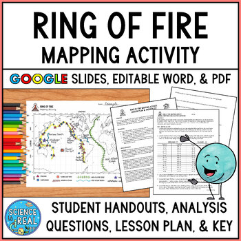
⭐ ⭐ ⭐ ⭐ In this fun and engaging ring of fire mapping activity, students plot the coordinates of past earthquakes and volcanoes along the ring of fire using an easy to read Pacific-centered world map. Students will then draw other geologic features on their maps such as trenches, mountain ranges, hot spots, and mid-ocean ridge. After the map is complete, students will answer 25 analysis questions. Editable MS Word version, PDF version, and Google Slides version are all included!
I complete this with my own Earth Science students every year and they really get a lot of learning and enjoyment out of it! The clear step-by-step directions makes this a great independent assignment! Click on the preview to see what the map will look like finished!
⭐ Includes ⭐
•Detailed Lesson Plan
•Blank Map with Legend
•Example Completed Map
•Step-By-Step Student Directions
•25 Analysis Questions
•Answer Key for Map and Questions
PDF Version, Editable MS Version, and Google Slides Version (with drag and drop for map) are all included in your download!
By the end of this activity, students should be able to...
• Map volcanic and earthquake activity and relate it to the positions of the Earth's tectonic plates
• Discover and identify the ring of fire and describe the events that occur along the ring of fire
• Plot and describe the geologic activity that occurs at hot spots
• Plot and describe the events at faults, trenches, ridges, mountains, and hotspots
• Predict the approximate locations for future volcanic, earthquake, and hotspot activity
• Describe general safety precautions and natural disaster preparedness for future earthquake and volcanic activity
I like to use this activity after viewing this Ring of Fire video with worksheet!
⭐ Ring of Fire Documentary Video Worksheet with Free SchoolTube Video Link
❤️ CLICK TO FOLLOW SCIENCE IS REAL! ❤️
Get News of New Products, Discounts, Updates, and Sales
Science Is Real! Terms of Use (TOU):
By purchasing this product, you own a license for one teacher only for personal use in their own classroom. Licenses are non-transferable and therefore cannot be passed from one teacher to another. If the teacher who purchased this license leaves the classroom or changes schools, the license and materials leave with that teacher. No part of this resource is to be shared with colleagues or used by an entire team, grade level, school or district without purchasing the correct number of licenses. If you are a coach, principal or district interested in transferable licenses that would accommodate yearly staff changes, please contact me for a transferable license quote at ajcatts@gmail.com or scienceisrealeducation.com
Please note - all material included in this resource belongs to Ana Catts. By purchasing, you have a license to use the material, but you do not own the material. You may not upload any portion of this resource to the internet in any format, including school/personal websites or network drives unless the site is password protected and can only be accessed by students, not other teachers or anyone else on the internet.
Purchase of the product is for single classroom use by the purchaser only. It is a violation for individuals, schools, and districts to redistribute, edit, sell, or post this item on the public Internet or to other individuals. Disregarding the copyright is a violation of the Digital Millennium Copyright Act and subject to legal action.
-By purchasing this product you acknowledge that you have read and understood the Terms of Use.
Dude Dot Clipart by (C) Sarah Pecorino Illustrations
HAPPY SCIENCING!
Connect with Me!
Facebook
Science Is Real Website
TpT Store
❤️ CHECK OUT MORE GREAT THINGS FROM SCIENCE IS REAL! ❤️
⭐ EARTHQUAKES AND VOLCANOES ⭐
• Earthquakes and Volcanoes Growing Resource Bundle
• Earthquakes and Volcanoes 5E Unit Plan - Secondary Science
• Volcanoes Lab - Types of Volcanoes Edible CER Lab - Low Prep and Fun!
• Types of Faults Reading Comprehension, Worksheets, and Graphic Organizer
• Earthquakes and Volcanoes Lab Stations
• Earthquakes and Volcanoes PowerPoint, Student Notes, & Kahoot
• Earthquakes and Volcanoes Webquest
• Earthquakes and Volcanoes Assessments - 100% Editable!
• Volcanoes Powerpoint with Student Notes, Questions, and Kahoot
⭐ PLATE TECTONICS ⭐
• Plate Tectonics Growing Discount Bundle
• Plate Tectonics Lab - Modeling Plate Boundaries and CER Edible Lab Activity
• Plate Tectonics Lab Stations - Student-Led Stations Lab
• Plate Tectonics 5E Unit Plan - Secondary Science
• Plate Tectonics Bell Ringers or Exit Slips
• Plate Tectonics Printable Board Game
• Plate Tectonics PowerPoint with Student Notes, Questions, and Kahoot
• Plate Tectonics Assessment - Question Bank & Pre-Made Assessments 100% Editable


