South America Geography Activity | Interactive Bulletin Board Continent Project
- PDF
- Easel Assessment
Description
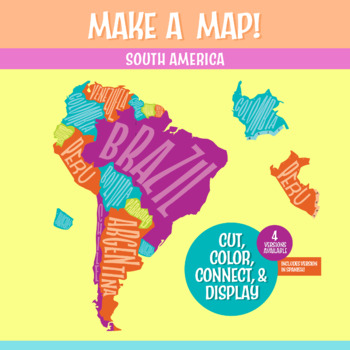
A South America map that you build as a giant wall map! This is a fantastic method to learn the South American countries. Both English and Spanish versions are included. When finished, you'll have a gorgeous map on display, clearly showing the South America countries. Your students can research a South American country, decorate each country, assemble the South American continent on your bulletin board or wall, and they will be all ready for a geography quiz.
The finished map is HUGE: the contiguous countries measure 27in W X 39in H. This map has been designed with a unique and simple system of numbered tabs, making it easy and fun for kids to piece together in your classroom. Complete illustrated step-by-step instructions are included.
There are four versions so you can customize this map for your needs:
1) Countries in color with a fun font for the country name—students simply cut out the countries and piece them together
2) Countries in color with a fun font for the country name in SPANISH—students simply cut out the countries and piece them together
3) Countries in color but otherwise blank—students can label and decorate before piecing the map together
4) Outline of countries (no color) and completely blank—totally open-ended for you and your students to choose the color and decoration
BONUS: This resource ALSO includes a self-checking EASEL Exit Ticket assessment with 12 multiple-choice questions (audio of the questions included for students who prefer to listen) which can be digitally assigned via multiple LMS systems including Google Classroom™.
This is a terrific geography project for kids to learn the South American continent. It's a simple introduction to South America and would work well with any continent study, Spanish lessons, studies of South American biomes, habitats of South America or South American wildlife, political maps, hands-on geography, a Montessori approach, geography trivia, and/or teaching world geography or South American geography.
There are 12 countries and 1 territory included: Brazil, French Guiana, Suriname, Guyana, Venezuela, Colombia, Ecuador, Peru, Bolivia, Paraguay, Argentina, Uruguay, and Chile.
You may also be interested in:
- South America Mini Version (cut-and-paste the countries onto a sheet of paper)
- South America Digital Version (drag and drop the countries to make the continent)
- Giant WORLD map (piece together world continents)
- USA giant wall map (piece together the US States)
______________________________________________________________
* Visit my store and click on the green star to be the first to know about new products, sales and freebies.
** Please remember to rate this product so that you earn TPT Credits for future purchases!


